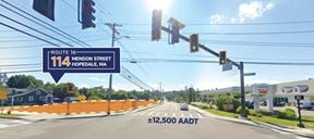
- For Sale Subject To Offer
- Property Type VacantLand
- Lot Size 0.57 Acre
- Date Updated Aug 28, 2025
Reach out to the broker for more info on lease terms and amenities
Highlights
- A monument sign is still erected on site.
- Cleared, level commercial lot: ±0.57 acres. (Please note there is an easement to the adjacent lot.)
- Lot currently has no structures on the property.
- Previous use: Gas station, trailer parking and trucking stop.
- Zoning: BUS - Business
False
Contacts

NAI Parsons Commercial Group - Boston
Location
Getting Around
-
Walk Score ®
22/100 Car-Dependent
-
Bike Score ®
36/100 Somewhat Bikeable
- City Uxbridge, MA
- Neighborhood Uxbridge
- Zip Code 01569
- Market Worcester Springfield
Points of Interest
-
Forge Park/495
9.54 miles
-
Mobil
3.81 miles
-
Cumberland Farms
4.21 miles
-
Helen Fuels Corporation
4.78 miles
-
Stop & Shop
5.47 miles
-
Speedway
7.20 miles
-
Sunoco
8.24 miles
-
Rapid Refill
8.67 miles
-
Gulf
8.83 miles
-
Citgo
9.76 miles
-
Rest Area SR 146 (South Bound)
3.65 miles
-
Weigh Station SR 146 (North Bound)
3.66 miles
-
Residence Inn Boston Franklin
9.63 miles
-
McDonald's
0.06 miles
-
Goodstuff Smokehouse
3.47 miles
-
TKO Pizza
3.59 miles
-
Depot Cafe
3.74 miles
-
Harry's Pizza
3.76 miles
-
Jumbo Donuts
3.84 miles
-
Dunkin'
3.92 miles
-
Subway
3.94 miles
-
Niko's Pizza and Chicken
4.85 miles
-
Foodworks
4.87 miles
-
Longfellow School
1.16 miles
-
Millville Elementary School
1.43 miles
-
Uxbridge High School
1.84 miles
-
Augustine F. Maloney Elementary School
2.97 miles
-
John F. Kennedy Elementary School
3.00 miles
-
Blackstone-Millville Regional Schools
3.01 miles
-
Blackstone-Millville Regional High School
3.33 miles
-
Our Lady of the Valley School
3.76 miles
-
Frederick W. Hartnett Middle School
3.83 miles
-
Uxbridge Public Schools
4.20 miles
-
Precious Ones Childcare Center & Preschool
4.06 miles
Looking for more in-depth information on this property? Find property characteristics, ownership, tenant details, local market insights and more. Unlock data on CommercialEdge.

NAI Parsons Commercial Group - Boston

